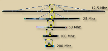
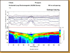
Horizontal Loop Electromagnetic (HLEM) Surveys Earthmaps Consulting offers HLEM surveys for soft sediment and hard rock applications. Earthmaps Consulting utilizes an in-house Apex Maxmin I-8 system, with a frequency range of 110 Hz to 14080 Hz. Earthmaps Consulting specializes in full 8 frequency surveys to allow optimal data inversion
and depth modeling, with an emphasis on high data quality. Earthmaps Consulting offers the following HLEM experience: Detection and mapping of paleo-channels in high, medium and low conductivity terrains across the Namibia for uranium, alluvial diamond and ground water exploration. Mapping of carbonatite pipes for REE exploration in northern Namibia Mapping of Ni-Cu sulphides in north-western Namibia Ground water detection in structural acquifers.
Presentation
"Ground Penetrating Radar (GPR) in the search for uraniferours paleo-channels." (pdf)
Presented at the Uranium Conference 23-24 October 2009, Swakopmund, Nambia.
Click to download (6.2mb) >>>
|
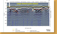
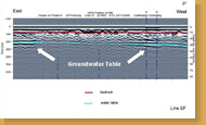
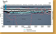
HLEM, paleo-channel (uranium)
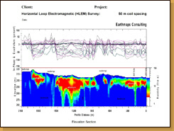
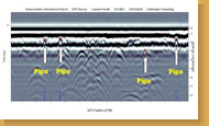
HLEM, paleo-channel (uranium)
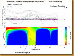
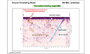
HLEM, carbonatite pipe.
|
Areva Bannerman Resources Corner Geophysics Namibia Geomine Consulting Namibia Extract Resources Gem Diamonds Green Mineral Resources Knight Piesold Consulting Kudu Minerals Namura Mineral Resources Northern Namibia Development Company Paladin Energy Reptile Uranium Sam Nujoma Marine and Coastal Research Centre | Sea Fisheries Institute Namibia Seal Consulting Engineers Swakop Uranium Valencia Uranium Windhoek Consulting Engineers Zebra Mining (Kristallgalerie) Farm Burgkeller Farm Gauss Farm Graslaagte Farm Hamakari Farm Onanis Farm Wolfskuppe Kollmitz Farming |